Figure 1. Land Elevation Profile of Orange County based on altitude data at 63 locations.
William R. Schell, Ph.D., Emeritus Professor
Environmental and Occupational Health
Graduate School of Public Health
University of Pittsburgh
Pittsburgh, PA
phone: 949 499 6444 e-mail: wschell1@home.com
Executive Summary
An independent environmental evaluation has been made of the expected pollution caused by airplane fuel burning from 240 commercial flights each day (one every 6 minutes) on the health of the population residing in the landing and take-off pattern (LTO) in Orange County, CA. The source of the proposed pollution is from conversion of the El Toro Marine Air Base to civilian airport operations. Calculations have been made to estimate the proposed pollutant input from fuel burning in the LTO pattern using as examples, two airplanes - the Boeing 727200 (three engines) and the Boeing 767-200 (two engines). If all aircraft were the Boeing 727, the amount of fuel burned would be 886,363 kg each day and, for the Boeing 767, the amount would be 395,703 kg. The fuel consumed daily in the LTO by the more efficient Boeing 767 would emit combustion products including hydrocarbons - 7,278,739 kg; carbon monoxide - 33,025,440 kg; nitrogen oxides - 5,751,360 kg, as well as soot particles, sulfur oxides, and other byproducts. These pollutant chemicals would be distributed in a hypothetical South Coast Air Basin "bath tub", defining the Basin as having an average ground level height of 350 feet above sea level with dimensions of 30 miles by 15 miles. When a meteorological inversion of 1200 feet above sea level is present, i.e., a "bath tub" lid, the Air Basin volume would be 3.018 x 10¹¹ m3. For carbon monoxide, nitrogen oxides and other contaminants, the concentration and exposure time are of particular importance to the health of people living in the region. Under meteorological conditions often prevailing in the South Coast Air Basin, the expected concentration value for carbon monoxide, 109 PPM, would require a limit in exposure time of only 15 minutes before chronic health effects were experienced (as recommended by World Health Organization (WHO).) For nitrogen oxides, the expected concentration value, 19.1 PPM, would exceed by 47 times the exposure for one hour as recommended by the WHO and for hydrocarbons, 27 PPM (no WHO guidelines available). In addition, the hydrocarbons would be accompanied by 1014 - 1015 soot particles per kg fuel at an average particle size of 20 nm (10-9m). These particles would interact with local fog and deposit a black oily film on buildings, plants and deep into the lungs of humans. The above pollutant calculations have been made without even taking into account the additional vehicle traffic, industrial sources, and smog from the Los Angeles Basin already spilling over into the South Coast Air Basin. Even before including these sources the additional pollutant chemicals from fuel consumption from LTO by a Boeing 767 can be expected, on days with inversion layers, to exceed the "safe" limits published by the EPA and WHO.
Introduction
The Orange County Board of Supervisors has made a proposal for the re-use of the El Toro Marine Air Base. The Board voted 3 to 2 for developing a major international airport and has initiated an Environmental Impact Report (EIR). The report on the air quality was prepared by the consulting firm of Mestre-Greve Associates, Newport Beach, California. An attempt has been made here to assess the validity and conclusions in the EIR concerning the noise and air quality changes in South Orange County resulting from the proposed commercial Airport. The number of take-off and landing events would eventually reach a frequency of every 3 minutes, 24 hours per day. A concerned resident of Orange County, CA, performed this independent evaluation of the appropriate parts of the EIR.
Background Information
The following questions should be posed and answered in a detailed evaluation of the potential environmental pollution, both noise and chemical, to the population residing in and near the airport and flight path of the large commercial airplanes to be used:
Of major importance to the pollution input into the Orange County air basin, in terms of synoptic meteorology, is the presence of an anticyclone which is a circulation of winds around a central region of high pressure - clockwise in the Northern Hemisphere. Anticyclones are important since they may be associated with episodes of poor air quality, in part because the downward movement of air can create atmospheric inversions causing chemical pollutants to accumulate. (Inversions occur when there is a change in the normal decrease in temperature of dry air with altitude of about 10 OC per kilometer). The air pollutants build up further due to light winds of high-pressure areas resulting in low rates of air movement, i.e., ventilation from urban areas. These inversions may be 900-1200 feet in elevation over the near shore and adjacent regions in Orange County. The inversions, coupled with the regional topography, would cause disastrous pollutant effects to the health of certain population groups residing in the hills and valleys of South Orange County. Inversions can be recognized easily where the fog or brown colored layer of pollution abruptly ends at an altitude of about 1000 feet. The brown coloration is caused by the presence of nitrogen oxides, ozone, sulfur oxides, and other pollutants and was repeatedly observed in JulySeptember 1999 by the author (Schell, 1999).
Terrain Effects
Terrain features of a landscape such as mountains, valleys and canyons describe the area and size of an air basin due to specific boundaries that limit the long-range transport of pollutants. The term ventilation of the enclosed air mass provides an outlet for the build-up of pollutants. On the other hand, the natural barriers together with meteorological inversions, would limit the dispersion of pollutants resulting in build-up of health affecting concentrations. A prime example of air pollution in one of the most affected regions in the USA is the Los Angeles air basin bounded by mountains to the north and east of the city. Only limited and gradual changes in elevation occur from the coast line (Santa Monica) to the mountains ( Pasadena). To the south east, a canyon through the mountains leading to Riverside provides a conduit for transport of pollutants in the air basin when the prevailing winds are westerly from over the ocean. The occasional Santa Ana winds originate from high temperature regions to the East and reverse the general prevailing wind structure. Such winds increase the pollutant levels since the ventilation of the air basin is limited and the pollution effects increase. Some of these pollutants, generated in Los Angeles County, also are transported south toward Irvine, the El Toro air base and Orange County in general. Similar conditions to those in LA exist at Santiago, Chile where the Andes Mountains restrict the ventilation and severe pollution occurs.
The most health-threatening episodes of industrial air pollution have been associated with high pressure areas. Very strong atmospheric inversions associated with anticyclones trapped chemical pollutants leading to lethal pollutant concentrations at the Meuse Valley, Belgium 1-5 December 1930, Donora, PA 25-30 October 1948, and London 5-9 December 1952 (Williamson, S.J.,1973). In each of these toxic conditions, stagnant air and fog were present and the build-up of pollutants caused many deaths from respiratory illness, and lung damage to the elderly and to the children. Could similar conditions exist in South Orange County where one of the largest retirement communities in the country exists in the flight path only 3.5 miles from the proposed El Toro runway?
In southern Orange County from Newport Beach to Camp Pendleton, a series of hills and mountains exist close to the ocean with elevations of from 300 to 1000 feet. These hills and mountains include the San Joaquin Hills, Sheep Hills, Laguna Coast Wilderness Park, Aliso and Wood Canyons Wilderness Park, Crystal Cove State Park and the San Juan Hills. To the east north-east of these coastal hills at about 15 miles across the valley, a series of mountains exist which rise to levels of 1000-6000 feet. To the north and north east are the Chino Hills, Peralta Hills, Santa Ana Mountains, southward through the Cleveland National Forest and further south to the Camp Pendleton Mountains inland from the ocean. In addition to the hills and mountains, important topographic details are the several canyons that bisect the coastal mountains.
What do these topographic features have to do with the potential frequency of commercial airlines penetrating the air space over the valleys and hills at a predicted rate of one every three minutes, 24 hours per day? The answer to this question is related directly to the proximity of the ocean, the topography, wind direction, how the local meteorology is affected and the use of large quantities of airplane fuel in the air basin.
Water bodies warm and cool more slowly than the land. As a result, in coastal areas, sea breezes may be produced when air over land warms during the day and consequently rises, to be replaced by cooler and moist air coming from over the water. At night, as the land cools to a temperature lower than the water body, air cooled by the land flows toward the water. Areas down wind from the water body may receive more precipitation than surrounding areas, because the water bodies supply moisture to the air more rapidly that does the land. Surface topography also influences the winds, precipitation and temperature. Valley winds can be created as air along a hillside is warmed during the day and rises, drawing air up the valley, or as air cooled at night flows downhill toward the valley bottom. In each of these cases significant fog layers occur.
The windward side of a mountain range often receives extra precipitation due to orographic uplifting and the associated adiabatic cooling of humid air. The leeward side of such a range tends to be dryer and warmer as air that has already lost moisture on the windward side, descends and warms adiabaticaly. This rain shadow effect is prominent along coastal mountain ranges. The result of the topography influence can be summarized in that conditions are created where ocean moisture and land interaction creates fog, high humidity and precipitation in much of the South Orange County region. Ocean fog penetrates the canyons and valleys where a general inversion layer cap occurs at some 900-1200 feet. Commercial airliners release toxic by-products and unburned fuel that is entrapped by the moist humid conditions. The residence time of these contaminants is long and without ventilation of the air basin, serious health effects to the population can occur. What is needed are predictive model calculations of the residence time in the atmosphere of the airplane fuel by-products caused by the build-up each three minutes from linear dispersal of contaminants, i.e., during the flight path from Dana Point to El Toro and during the flight take-off pattern.
Air Basin Calculations
To address the problem of contaminant build-up and loss from airplane use in the air basin, a simple prediction model must be developed. The landing and take-off cycle (LTO) defines the airport activity and the aircraft emissions. Other emissions are taxi time and gate time when the aircraft engines are operated at about 7% power. (TERC, 1999). The source terms are that a single take-off and a single landing event will occur each three minutes when the airport maximum use is achieved. Since the major fuel use is during take-off (TO), the first calculation will be made for one take off each six minutes, or 240 (TO) each day and the second calculation for the landings. Consider, for example, the Boeing 727-200 fuel use rate under different operating conditions (Arrow Energy and Hamilton Aviation). The range is approximately 2600 nautical miles (nm) and the fuel capacity used for this hypothetical flight is 9730 gallons. Assuming 1/8 of the fuel is used on TO (TERC,1999), then (9730 x 0.125 = 1216) gal. are needed for each TO and climb to altitude. Assuming that each day there are 240 TO and each one uses 1216 gal, we have 291,840 gal. fuel used each day on take-off.
On landing we can make an approximation by 9730 1216 = 8514 gal. average fuel used over 2600 nm (nautical miles). Then the amount used per landing is 8514/2600 = 3.27 gal/nm. For the glide path of 10.4 nm, Dana Point to El Toro, the fuel used is 3.27 x 10.4 = 34 gal/landing. The daily fuel used in landing then is 34 gal x 240 landings = 8160 gal. Thus, the total fuel used for take-off and landings is 291840 + 8160 = 300,000gal/day (US) injected into the environment from aircraft flight operations at El Toro. At a conversion rate of 6.5 lbs per gallon of fuel, we have a potential aircraft fuel use contamination of 1,950,000 pounds each day.
A second calculation has been made using recent information on a newer airplane, the Boeing 767-200, with 2 rather than 3 engines, as was used in the previous calculation. The new engines are General Electric CF6-80A2 high bypass, turbofan, IPCC, 1999. Contamination near the El Toro airport includes time and rates of fuel burning for the modes take-off, climb out, approach, idle - and the resulting effluent pollutant chemical emissions. Table 1 shows the data and calculations of the fuel use during take-off and landing. Table 2 shows the calculations of the resultant pollutant effluents from fuel burning, namely hydrocarbons HC, carbon monoxide CO, nitrogen oxides NOx and smoke number SN.
The newer design engines show a better fuel efficiency and commensurate reduction in emission by-products. However, only limited data is available for several additional pollutants caused by aircraft operations in the landing and take-off cycle of the regional South Coast Air Basin. The aircraft engine emission value for smoke number SN is about 0.04 g/kg fuel burned. This organic soot is formed from incomplete combustion of fuel passing through the turbofan engines and consists of many carcinogenic organic
Table 1. Data and calculations for fuel use during
take-off and landings, LTO. TO-take off, CLO-climb to altitude, Appr -Approach
to runway, Idle-Idle waiting for boarding, taxi and runway clearance.
IPCC, 1999.
| Time-mode
(min) mode |
Fuel flow
(kg/sec) |
Fuel use
(kg/engine) |
Total fuel consumed (kg)/LTO | Total kg/day
(240) LTO |
| 0.7 TO | 2.353 | 98.826 | 197.652 | |
| 2.2 Cl O | 1.913 | 252.516 | 505.032 | |
| 4.0 Appr | 0.632 | 151.68 | 303.36. | |
| 26 Idle | 0.205 | 321.36 | 642.72 | |
| TOTAL / LTO | 1648.764 | 395,703 |
Example: Total fuel use for each landing and take-off 1648.764 x 240 LTO per day = 395,703 kg per day x 2.2 lbs/kg = 870,546 lbs per day.
Table 2. Emission of pollutants resulting from aircraft
fuel burning in the El Toro landing and take-off air space assuming one
event each 4 minutes, 24 hours per day. IPCC, 1999.
| Time-mode
(min) mode |
Hydr Carb
(kg/sec) |
Total HC/2eng
(kg) |
Carb Oxid
(kg/sec) |
Total CO/2eng
(kg) |
Nitr Oxidx (kg/sec) | Total NOx/2eng
(kg) |
| 0.7 TO | 0.08 | 6.72 | 0.52. | 43. | 28.06 | 2357 |
| 2.2 Cl O | 0.09 | 23.76 | 0.52 | 137 | 21.34 | 5633 |
| 4.0 Appr | 0.20 | 96.0 | 2.19 | 1051 | 8.97 | 4305 |
| 26 Idle | 9.68 | 30202 | 43.71 | 136375 | 3.74 | 11669 |
| TOTAL / LTO | 30,328 | 137,606 | 23,964 | |||
| Total/ day | 7,278,739 | 33,025,440 | 5,751,360 |
Example: Total HC emission TO=0.08x42 sec =3.36kg/engine x2=6.72 kg; ClO=0.09x132=11.88kg/engine x2=23.76; Appr=0.20x240sec=48kg/engine x2=96kg; Idle=9.68x1560=15100kg/engine x2=30202kg x240 LTO/day = 7,278,739.
compounds. The size distribution of particles peaks at 20-30 nm and the concentrations range between 10 6 and 107 particles per cm3. A general emission range for most engines operating in the current commercial fleet is 1014-1015 particles per kg fuel burned, IPCC 99. These particles provide nucleation sites for both organic liquid droplets and moisture droplets. Aggregation of particles results in black soot depositing on houses, cars, lawn furniture, swimming pools, etc. especially in humid or foggy conditions. Because of the size distribution, any inhaled particles penetrate deep into the lungs with resultant increase in respiratory conditions in older people and children.
Conceptual Model
Airports have been identified as major pollution sources in the USA with the Los Angeles International Airport being the second largest industrial smog source in the Los Angeles Area, ranking between the Chevron and ARCO refineries. NRDC, 1999. The practical questions we must address are: (a) what level of pollution chemicals in the local environment can be tolerated without causing health effects to the most vulnerable of the population? (b) what is the expected pollutant concentration resulting from an increased volume of aircraft flights in the Orange County Air Basin?
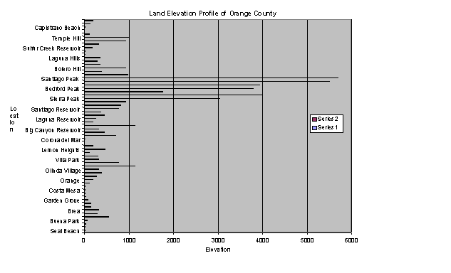
Let us consider that the Air Basin in South Orange County that has dimensions of about 15 miles wide and 30 miles long, bounded by mountains to the East and hills to the West with the ocean beyond. The top and bottom boundaries are, respectively the atmospheric inversion layer of about 1200-ft and the uneven topography at the ground. The average height of the uneven topography using 63 data elevation points in Orange County have been estimated to be about 350 feet, see Table 1. AAA,1997. The high mountains on the eastern boundary of Orange County, i.e., above 1200 feet are classified as outliers and these seven data points are not included in the average, see Figure 1. Thus, the volume of the flight path within the Basin is calculated to be 3.018 X 10¹¹ m3.
This is our "bath tub" with the spillover lid, the inversion, at the top and the drain, or escape zone where contaminated air can ventilate, at the bottom. The aircraft fuel contaminates this "bath tub" when the airplane descends to below the inversion layer. Other polluting contaminates from Table 1 and 2 for a single day of airport use are:HC 27 ppm; CO 109 ppm; NOx 19 ppm. For CO, and NOx the population exposure time is of particular concern. The World Health Organization provides the following exposure limiting values for CO: 100 ppm-15 min; 60 ppm-30 min; 10 ppm-8 hr. For NO: 0.4 ppm -1 hr; 0.15 ppm -24 -hr, Brimblecombe, 1996. The values estimated for CO and NOx exceed the exposure dose by as much as 47 times. Thus, even before the addition of vehicle traffic and industrial sources, the contribution to the overall pollutant chemicals provides more than the "safe" limits given by the EPA and WHO regulations.
Transport of pollutant chemicals and smog from Los Angeles South into the Orange County Basin, as well those locally generated, provides much greater chemical exposure dose to the sensitive population. The key to build-up of the concentrations of fuel by-products is the rate at which they are introduced and removed i.e., the residence time of each constituent in the Basin. Since the build-up of contaminants can occur from the flights each four minutes during a 24-hour period, the rate of buildup in the "bath tub" from the airplane fuel burning and the rate of loss from all sources must be modeled. Since the fuel is heavier than that of air, the net flux of much of the unburned fuel is vapor that can interact with fog droplets. In addition, the soot (smoke) particles form nucleation sites where more moisture condenses as fog. When the particles are sufficiently large, droplets form precipitation and may or may not be removed from the atmosphere because of the turbulent mixing within the inversion layer. From these data a predictive model for the future can be constructed where the concentration of pollutants breathed by the inhabitants of the region can be calculated (a source term of 1.950 x 10⁶ pounds of fuel burned in a volume of 3.018 x 10¹¹ m3).
Health effects of pollutants
Health effects of pollutants may be divided into two major classes
acute exposures and chronic exposures. Acute health effects are experienced
immediately or within a few hours. Chronic effects may only become apparent
after an extended period of time, typically months or years. For a given
air pollutant, the chances of a person experiencing a health effect generally
increases as the exposure concentration and duration increases. However,
it is difficult to generalize on effects since there are many individual
differences in exposure rate and dose. Epidemiological studies and clinical
Figure 1. Land Elevation Profile of Orange County
based on altitude data at 63 locations.
studies have been made to estimate health effects for a number of pollutants, many of them are associated with airport operations. The specific air pollutants associated with airports are ozone, carbon monoxide, nitrogen oxides, volatile organic compounds, particulate matter and sulfur oxides. Other pollutants include polycyclic aromatic hydrocarbons found in the particulate emissions and certain VOCs. (EPA, 1999). Aerosols, dust and soot are also found.
The most susceptible groups for health effects from atmospheric pollutants are those people over 55 years and young children. As mentioned above, one of the largest concentrations in the USA of retired people is at Leisure World, located only 3.5 miles from the airport and in the landing path. The health effects of air pollution that these people will encounter are shown in Tables 3 and 4 (EPA, 1999). The projected increase in pollutants from 1990 to 2010 is about 68% for LAX. Part of these pollutants will affect Orange County due to the spill-over from the LAX air basin. In addition, these retired people will have the local effects of El Toro in the form of fuel spills, pollutants such as carbon monoxide, soot particles and oily black unburned fuel.
Conclusions
In trying to review the pollution effects of a potential commercial airport at the El Toro Marine Air Base, keen reservations concerning the environmental pollution must be expressed. The topography and meteorology must be considered in terms of noise and pollutant input to the air basin. Further work is needed on a predictive model for exposure dose. The health effects of the pollutants including ozone, nitrogen oxides, sulfur oxides, carbon monoxide, volatile organic compounds, particulates, soot and dust can cause severe illnesses including respiratory problems, and lung and cardiovascular effects, especially in older people and children.
Because of the large amounts of fuel used in the flight landing and take-off pattern when the airport would be fully operational, the effects of the pollution and noise would affect the population extensively. If a commercial airport is constructed at El Toro, the Board of Supervisors should be held responsible by those of us lucky enough to have a very strong constitution, and a second home far away where we can recover periodically from this environmental insult.
References
The references included below provide a basis for acquisition of data in support of the above report. Every effort has been made to evaluate the information objectively and to help other investigators utilize the Internet and other information sources in their future evaluations.
Arrow Energy Inc. National Aviation Fuel Supplier, Saline, MI 48176
e-mail: arrow@arrowenergy.com
EPA420-R-99-013, April 1999. Evaluation of Air Pollutant Emissions from Subsonic
Academic Press, New York and London, 346p.
Hamilton Aviation. http://www.hamiltonaviation.com/salelease/specs/B727ADV.htm
Purvis Brothers Inc, 1999. Aviation Civilian Turbine Fuel Specifications. http://www.nauticom.net/www/macpjr/avturbospec.htm
Schell, W.R. 1999. Frequency of fog and other meteorological conditions observed and recorded from Monarch Summit II, Laguna Niguel, CA. Personal Scientific Notebook
TEOC, 1999. The Environmental Organization, Copenhagen. 17p plus 5 Appendices.e-mail: beck@idt.net., http://hudson.idt.net/~beck/index-engelsk.htm
Williamson, S.J.,1973. Fundamentals of Air Pollution. Addison Wesley Publishing Co.,
IPCC, 1999. Aviation and the Global Atmosphere. A special report of the IPCC Working
Fund. http://www.nrdc.org/nrdc/find/trairpov.html.
AAA, 1997. Automobile Club of Southern California, Orange County.
Brimblecombe, P., 1996. Air Composition and Chemistry. Second Edition. Cambridge
Environmental Series, 6. Cambridge University Press, 253p.
-------------
8 September 1999, Laguna Niguel, California - WRS.
Revised 20 Dec 1999.
| Table 3. Land elevation at selected sites in Orange County, CA. AAA Map of Orange County, 1997. | ||||||||
| Location |
|
Location |
|
|||||
| Seal Beach |
|
Laguna Reservoir |
|
|||||
| Los Alamitos |
|
Lambert Reservoir |
|
|||||
| Cyprus |
|
Siphon Reservoir |
|
|||||
| Buena Park |
|
Santiago Reservoir |
|
|||||
| Los Coyotes Hills |
|
Walnut Canyon Reservoir |
|
|||||
| La Habra |
|
Scully Hill |
|
|||||
| Brea |
|
Sierra Peak |
|
|||||
| Fullerton |
|
Pleasants Peak |
|
|||||
| Anaheim |
|
San Juan Hill |
|
|||||
| Garden Grove |
|
Bedford Peak |
|
|||||
| Westminster |
|
Bald Peak |
|
|||||
| Huntington Beach |
|
Modjeska Peak |
|
|||||
| Costa Mesa |
|
Santiago Peak |
|
|||||
| Fountain Valley |
|
Trabuko Canyon |
|
|||||
| Santa Ana |
|
Lake Forest |
|
|||||
| Orange |
|
Bolero Hill |
|
|||||
| Placentia |
|
Laguna Hills |
|
|||||
| Yorba Linda |
|
Mission Viejo |
|
|||||
| Olinda Village |
|
Laguna Hills |
|
|||||
| Robbers Peak |
|
Emerald Bay |
|
|||||
| Rattlesnake Peak |
|
Laguna Beach |
|
|||||
| Villa Park |
|
Sulfur Creek Reservoir |
|
|||||
| El Modena |
|
Laguna Niguel |
|
|||||
| Tustin |
|
Laguna Hill |
|
|||||
| Lemon Heights |
|
Temple Hill |
|
|||||
| Irvine |
|
South Laguna |
|
|||||
| Newport Beach |
|
Dana Point |
|
|||||
| Corona del Mar |
|
Capistrano Beach |
|
|||||
| Pelican Hill |
|
San Juan Capistrano |
|
|||||
| San Juaqiin Reservoir |
|
San Clemente |
|
|||||
| Big Canyon Reservoir |
|
outliers | total | |||||
| Signal Peak |
|
Sum |
|
|
|
|||
| Sand Canyon Reservoir |
|
|||||||
| AVE |
|
|||||||
| Subtract 7 outliers>1200 | ||||||||
| AVE |
|
|||||||
Table 4. Representative health effect of air pollutants
(EPA, 1999, Williamson, 1973)
| Representative Health Effects | |
| Ozone
Carbon Monoxide
Nitrogen Oxides Particulate Matter
Volatile Organic Compounds
Sulfur Oxides |
Lung function impairment,
effects on exercise performance, increased airway responsiveness, increased
susceptibility to respiratory infection, increased hospital admissions
and emergency room visits, and pulmonary inflammation, lung structure damage.
Headaches, faintness and cardiovascular effects, especially in those persons with heart conditions (e.g., decreased time to onset of exercise-induced angina). Idle airplane power setting is 10 times the pollution contribution as for 85% power (TEOC, 99). Lung irritation and lower resistance to respiratory infections. Premature mortality, aggravation of respiratory and cardiovascular disease, changes in lung function and increased respiratory defense mechanisms. Eye and respiratory tract irritation, headaches, dizziness, visual disorders, and memory impairment. Pungent respiratory irritant, below 25 ppm it affects only the upper respiratory system. It does not cause eye irritation at concentrations below 10 ppm, but the threshold is reduced when it is experienced in combination with aerosols. The combination of sulfur oxides and aerosols, such as moisture, penetrate deep into the lung. The moist air in the bronchioles and alveoli establishes conditions appropriate for the oxidation of SO2 and the formation of sulfuric acid where particles are lodged (Williamson, 1973). |
Table 5. Representative environmental effects of air
pollutants (EPA, 1999)
| Pollutant | Representative Environmental Effects |
| Ozone
Carbon Monoxide Nitrogen Oxides
Particulate Matter
Volatile Organic Compounds |
Crop damage, damage
to trees and decreased resistance to disease for both crops and other plants
Similar health effects on animals as on humans. Acid Rain, visibility degradation, particle formation, contribution towards ozone formation Visibility degradation and monument and building soiling, safety effects for aircraft from reduced visibility. Contribution towards ozone formation, odors and some direct effect on buildings and plants |