The existence of this report created headlines when a draft version surfaced in August, 2000.
The following document is still marked "Draft", but is the final version submitted to the FAA.
Analysis of the report is provided in an e-mail from former Marine Colonel Tom O'Malley.
Herman Bliss, Manager of the FAA Western-Pacific Region Airports Division, previously refused to provide this report to Supervisor Tom Wilson. The report was obtained by ETRPA through its contacts.
Air Traffic Control
Impact of the OCAA Proposal
for Civil Aviation
at El Toro
Tess Brothersen
Kevin Gormley
Danijela Hajnal
Jonathan Hoffman
17 May, 2000
Background:
The Orange County Airport Authority (OCAA) has presented AWP with a draft proposal to re-open the former MCAS El Toro (NZJ) for civil aviation. AWP is responsible for "evaluating the proposal from the standpoint of safe and efficient use" of the airport and the surrounding airspace. CAASD has been asked by AWP-530 to assist this effort by a quantitative analysis of the current traffic around the proposed airport, modeling the proposed traffic at El Toro, and estimating the proposed impacts of the additional traffic.
Approach
An analysis of this type requires:
Output metrics for the study were:
Operating Environment
The nature of the airspace design problem is defined by several general principles: terrain, surrounding traffic, and the likely users of the airport.
The most immediately apparent feature of NZJ is its proximity to Santiago Peak, 5720 feet above sea level, and other high ground to the east of the airport. This greatly constrains the arrival and departure procedures. An aircraft must be able to climb more than 420 feet per nautical mile to depart from runway 7. To the north and east, the Minimum Vectoring Altitudes (MVA) range from 4,000 to 7,000 feet. It is impractical to run aircraft below this altitude, since the controller has no flexibility to maneuver the aircraft to separate it from other traffic. Noise considerations dictate that runway 7 be used as the primary departure runway, nevertheless.
NZJ is only 7 nautical miles from John Wayne Orange County airport, which greatly restricts mobility to the west and north of the airport. LAX is to the northwest, and the airspace about 13 nmi north of NZJ is blocked from 8,000 ft to 13,000 ft by LAX arrivals from the east. Between NZJ and this flow are several Victor airways, heavily used for arrivals to SNA, LGB, and LAX from the south, and a pair of VFR flyways. To the south, there is very little low-altitude traffic. There are a great many overflights between 8000 and 12,000 feet inclusive.
Traffic at the new airport is forecast to be almost exclusively jets. This simplifies the problem by reducing the number of different arrival and departure routes that must be developed.
All arrivals were brought in from the south to runway 34, via a new fix aligned with the runway 13 nmi out. TANDY arrivals, from the north and west, passed by way of Santa Catalina VOR, south of the SNA traffic. Oceanside arrivals, mostly from Mexico, came via AREBA fix. Arrivals from the east, over HEC, did not join the KAYOH flows to SNA and LGB, but stayed south, east of Santiago Peak, then over FYTER, imitating the arrival pattern when NZJ was landing Marine jets.
Departures from runway 7 veered south to avoid the mountain. Departures to the east turn left for TRM transitions and proceed directly. Departures to Las Vegas turn right to Seal Beach (SLI), then Pomona (POM), and on to Daggett (DAG). Thus, they join the departure flows out of SNA. Flights to the north, along the West Coast, join the Channel 1 departure out of SNA, passing over the LAX VOR, then via existing routes in the ARTCC, above SCT airspace.
Departures from runway 34 maintain the runway heading for 11 miles, as specified in the Master Plan, and then headed to CACTS intersection (not currently used for departures). They then turn right to Paradise VOR (PDZ) if they are heading south or east, or north to POM. There are two problematic areas on this departure. First, maintaining the runway heading causes the departures to pass much closer than 3 nmi to the SNA arrival stream. Second, LAX arrivals occupy the space between CACTS and POM from 8,000 to 13,000 ft, so climbing above 13,000, out of SCT, between these points would be necessary.
Results
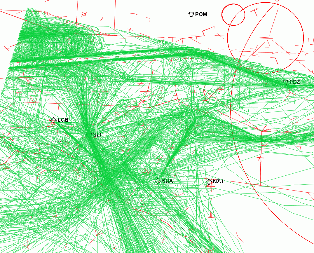
These four figures are derived from the Garden Grove radar, showing aircraft of concern to Coast area. The red lines in the background are the video map seen by the controllers working the area. The green lines are radar track data for the entire day. Figure 1 shows the arriving traffic in the SCT and Figure 2 shows the departing traffic in the SCT.
Figure 1. Arrivals into the SCT
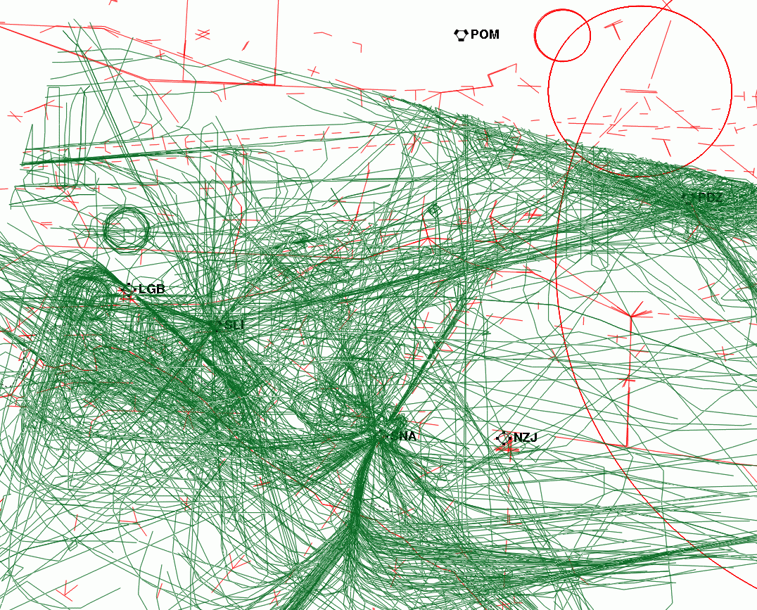
Figure 2. Departures out of the SCT
Figure 3 shows traffic to SNA and LGB airports. There is substantial traffic from SNA to the north and south of El Toro. To the east of El Toro, there is relatively little traffic, but there is mountainous terrain.
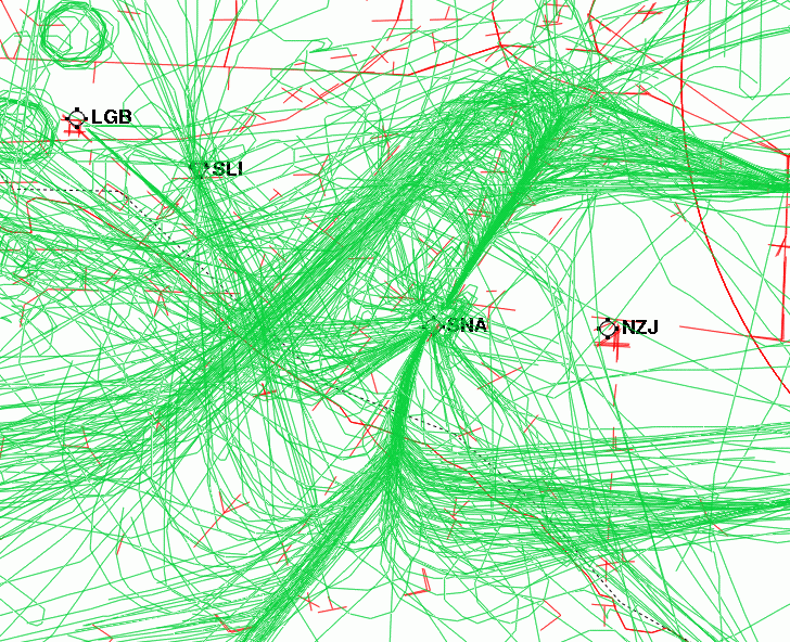
Figure 3. SNA and LGB Traffic through the SCT
Figure 4 shows LAX departures and arrivals going through the SCT. There is a heavily traveled flow of westbound arrivals about 15 nautical miles north of El Toro. To the west and south of El Toro, the LAX arrival route from San Diego and points south passes over the Seal Beach (SLI) navigation aid.
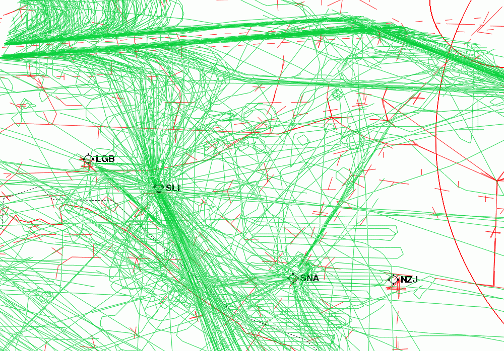
Figure 4. LAX Traffic through the SCT
The workload on air traffic controllers is not solely determined by the number of aircraft under control at any given time. The work of separating aircraft is also increased by the tendencies of aircraft flight paths to converge with one another. SDAT calculations of convergences of aircraft are presented below. The separation minimum for aircraft is 3 miles laterally, so if we examine the occurrences of aircraft passing between 3 and 5 miles apart, we can count the cases in which controllers have separated aircraft.
Figures 5 and 6 show convergences of aircraft within 5 nmi of each other. The traffic sample is from 1700Z to 1900Z. This period, from 10:00 AM to12:00 PM local time, is a typical heavy period during the day. Figure 5 is current traffic only; figure 6 includes forecast NZJ traffic. This is an estimate of the work that must be done by the controllers in the area to separate aircraft. The red lines in the background are the video map seen by controllers working the area. The location of each convergence is marked by a star; dark blue stars indicate closer convergence than light blue stars.
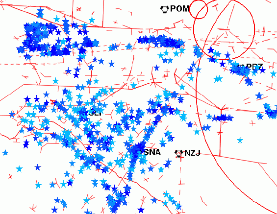
Figure 5. Aircraft Convergences in the Current System
In Figure 6, the trajectories of NZJ arrivals and departures are shown in light and dark green, respectively. As is clear from the picture, the addition of the NZJ traffic has a significant impact on the north side of the airport. Most conspicuously, every departure from Runway 34 is marked shortly after takeoff, indicating that the departure route from that runway is explicitly in conflict with arrivals to SNA.
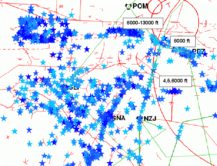
Figure 6. Aircraft Convergences with El Toro Traffic Added
These two hours, given current traffic, had 1297 convergences. With
the addition of the 26 NZJ arrivals and departures in that period, the
number of convergences rose by 153, which may be interpreted as a 12% increase
in the aircraft separation work demanded of the controllers. This increase
in workload continues through the day. Table 1 and Figure 7 show the day
broken into 2-hour periods.
Table 1. Increase in Convergences due to NZJ Traffic
|
|
|
|
|
|
|
|
| 1300-1500Z |
6am-8am
|
20
|
464
|
538
|
74
|
15.9%
|
| 1500-1700Z |
8am-10am
|
22
|
978
|
1,079
|
101
|
10.3%
|
| 1700-1900Z |
10am-12pm
|
26
|
1,297
|
1,450
|
153
|
11.8%
|
| 1900-2100Z |
12pm-2pm
|
24
|
1,165
|
1,302
|
137
|
11.8%
|
| 2100-2300Z |
2pm-4pm
|
11
|
1,085
|
1,166
|
81
|
7.5%
|
| 2300-2400Z |
4pm-5pm
|
4
|
563
|
590
|
27
|
4.8%
|
| Whole Day |
6am-5pm
|
107
|
5,552
|
6,125
|
573
|
10.3%
|
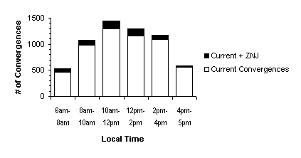
Figure 7. Convergence increases during the modeled day
A schematic of Victor airways in the vicinity of NZJ shows the possibility of conflicting flows more clearly. Figure 8 has the major victor airways in brown. To the east of NZJ, the arrival and departure routes do not cross the major airways. To the west, the routes lie below or along the airways. To the north, however, the CACTS departure crosses the airways at oblique angles, near but not at the convergence point, making the controllers task difficult.
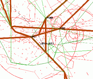
Figure 8. Major Victor Airways in the Vicinity of El Toro
Noise
The Integrated Noise Model (INM) was utilized to predict the noise effects of the proposed traffic at NZJ. The traffic provided by OCAA was used as the basis for the modeled traffic. Noise modeling requires more detail about the aircraft than were provided in the Master Plan, so the connecting airport for each flight was used to determine a likely airline to operate the flight. Likely engines for each aircraft were taken from representative airline fleets, as listed in J.P. International Fleets. The modeled flight tracks (above) were taken literally, with a nominal mile of across-track dispersion in lieu of any modeling of the actual tracks that the aircraft would fly. The 1990 U. S. Census was the source of the population data.
The DNL and CNEL contours for 55.0, 60.0, 65.0, 70.0, 75.0 and 80.0 dB were calculated. Figure 9 shows the DNL contours; CNEL contours were very similar. Table 2 shows the number of people living within each DNL contour, as well as the area of each contour.
Table 2. Population and Area within the DNL Contours
|
|
|
|
|
|
42108
|
42.855
|
|
|
12098
|
17.559
|
|
|
3002
|
7.954
|
|
|
74
|
3.714
|
|
|
66
|
1.642
|
|
|
72
|
1.215
|
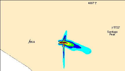
Figure 9. DNL Contours for Traffic at El Toro
FAR Part 150 states that areas with sound levels greater than 75 dB are not compatible with residential land uses. Table 2 shows that 138 people currently reside in areas that would fall within the 75 dB or above contour. Part 150 also states that homes located within the 65-75 dB contour must have an outdoor to indoor Noise Level Reduction of at least 25 dB. Typical residential construction can be expected to provide a NLR of approximately 20 dB. An additional NLR of at least 5 dB could be provided through sound insulation. An additional 3002 people are predicted to fall within the 65-75 dB range. It should be noted that the 1990 U. S. Census was used in the population predictions. While this data is out of date it is the most recent national census currently available. The number of people currently living within the predicted 65 dB or greater contour is likely higher than the number given here.
Conclusion
There is no immediate obstacle to runway 34 arrivals at NZJ. Likewise, runway 7 departures are feasible in the current system, as far as this level of modeling can ascertain. The secondary departure runway, runway 34, however, seems to require the use of airspace that is not available in the given configuration of the SCT.
Departures from some other runway than 7 appear to be necessary for the operation of NZJ as a civilian airport. First is the question of noise, which led to the designation of 34 as a secondary departure runway. More important however, is that the Master Plan forsees NZJ as serving long-distance traffic. This implies that there will be heavily-loaded aircraft departing NZJ in some situations. Heavily-loaded aircraft, especially on hot days, may not be able to climb at a rate sufficient for runway 7 departures. Some means of accomodating them will be necessary. This may be a redesigned departure procedure from 34, or perhaps the use of some other runway.