 ...Where
will they fly?
The question we are asked most frequently is, "Will the planes fly over my home?" If the answer had been known, Measure A might not have passed.
The answer is still unclear, because of a conflict between safety in the air and noise on the ground.
County says takeoffs will be to the east and north - but then where?
Pilots will decide. The FAA leaves the final decision to the pilots regarding takeoffs over Irvine.More about takeoffs to the northwest or west to avoid the mountains?
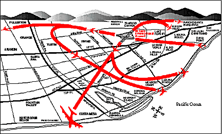
West takeoffs. Where might the planes fly from there? A graphic representation.
The AirLine Pilots Association objects to landings that approach from the north over Loma Ridge.
The FAA gives the pilots discretion to select the safest runway. Click here.
The FAA provides some input on El Toro, but will not take an "official" position at this time.
A Freedom of Information Act request, filed with the FAA, forced disclosure of a report on a meeting held April 30, 1996 between representatives of the FAA and the County's P&D Consultants, Inc. Concerning the takeoff path from the northbound runway (34) it notes:
"It is unlikely that MCAS El Toro Runway 34 departures would be allowed to continue northward due to the amount of traffic which already exists to the north."
"An official airspace review by the FAA could probably not be obtained until an airport option is selected and an Airport Master Plan was well underway or completed."
This would put aircraft over Irvine, UCI and portions of the Newport/Corona del Mar coast.
"A single DC-10 takeoff's pollution is equal to 21,530 cars driving one mile at 30 mph." - AReCO
"One aircraft takeoff burns up tens of thousands of pounds of fuel. A physicist remarked that one 747 takeoff is 'similar to burning down the local gas station and flying it overhead.'" - AReCO