Chronology of the changing plans
Map of the airport with the "green plan" - now the "airpark"
In December 1996, the Board of Supervisors approves a Community Reuse Plan for a 38 million annual passenger airport at El Toro. The plan states that "all commercial aviation operations at John Wayne airport would be moved to the MCAS El Toro site. JWA would operate, in the future, as a general aviation airport only." This 1996 plan is still incorporated as the "preferred alternative" in the Department of Navy's February 2000 Draft Environmental Impact Study for El Toro.
March 1998, the county announces that northerly takeoffs will no longer turn left before the mountains, and overfly central county as provided in the previous plan. Instead, they will continue straight north over the mountains. The proposed change is not submitted to the FAA and has yet to be approved. Both commercial pilots associations object for safety reasons.
In April 1998, county planners unveil a "Gateway to the 21st Century" proposal with high density development on the base, including a "Global Town Center", "International Trade Center" and other major facilities. The planning for this concept costs approximately $4 million. The concept is showcased in presentations throughout the county, in special county brochures and on the county website. It includes a choice of four options for dividing the air traffic load between John Wayne and El Toro.
In August 1998, the Global Gateway concept is scrapped and hastily replaced by the "Green Plan". The Gateway plan had received unfavorable reaction from the public and from business and community interests. It also produced more traffic than the non-aviation Millennium Plan, which had been receiving good grades for its combination of parks, open space, housing, educational facilities and employment opportunities.
In September 1998, the Board of Supervisors selects Option C, as their preferred alternative for further study. Option C is one of the four April 1998 options, which would share air traffic between John Wayne and El Toro. John Wayne would be mandated to handle flights of up to 500 miles and El Toro would handle longer flights - a so called perimeter rule. For the two-airport plan to work, it would be necessary to have a connecting people mover.
In March, 1999, county planners drop Option C, admitting that the people mover is unfeasibly expensive and that the air transport industry has objected, all along, to the perimeter rule and two-airport plan. The Board's next choice is Option B. El Toro will be made larger and John Wayne will shrink, perhaps to die on the vine and potentially close to commercial air traffic though this is not stated.
September, 1999, Supervisors begin to discuss a "community friendly airport", proposing that it be built in stages so that the eventual size and impact will not be as immediately evident. A proposal is floated, by Supervisor Coad, for an 18.8 million passenger airport by 2010 - with the second shoe to drop later.
December, 1999, Environmental Impact Report 573 is released. It is based on the March, 1999 plan. El Toro would handle 28.8 MAP and John Wayne would gradually shrink in utilization. The airport cost is almost doubled from previous estimates and significant noise impacts are admitted. Some northern takeoffs are diverted, on paper, away from Anaheim Hills.
March, 2000, Measure F is passed by a 67.3% landslide. Airport supporters consider other runway configurations and size limitations that might be more politically acceptable. Previously rejected V Plan and the new Pilots' Plan under consideration.
October, 2000, As the Board of Supervisors recertifies a corrected EIR 563 for the December 1996 38 MAP airport, ETRPA notes that this is still the official Community Reuse Plan under study by the FAA and Department of Navy. George Argyros tells the Airport Working Group that he favors a "neighborly" 12-14 MAP domestic airport.
October, 2001, EIR 573 is certified, and Airport System Master Plan is approved for a 28.8 MAP airport at El Toro and a reduction in the use of John Wayne. The supervisors vote, 3-2, to authorize spending for the first two phases, serving 18.8 MAP and handling 1.2 million tons of cargo.
| Option | A | B | C | D |
| % aviation acreage | 43 | 47 | 48 | 49 |
| John Wayne annual passengers -millions | na | 5.4 | 10.1 | na |
| Average daily vehicle trips to OCX* | 220 | 283 | 276 | 257 |
| Daily jet operations at OCX** | 513 | 824 | 510 | 787 |
| El Toro annual passengers -millions | 19 | 28.8 | 24 | 33.5 |
| Cargo - millions of tons/year | 1.25 | 2.01 | 2.02 | 2.07 |
John Wayne Airport has an estimated capacity to handle 15 million annual passengers and a temporary cap of 8.4 million under a 1985 agreement between the county and Newport Beach which expires in 2005. It is presently operating at less than 8 million passengers.
Under the adopted EIR 573, the county estimates that JWA usage will shrink "by almost half" of its current passenger" (ie. 3-4 MAP) and then rebound to 5.4 million passengers by 2020. There is considerable evidence that it eventually will be closed. Airlines are not expected to remain at John Wayne - with its curfews, severe noise abatement procedures, limited connections availability, and high costs - if they can move to El Toro. Click here for more about the impracticality of a two-airport system.
The Los Angeles Times of April 18, 1998 reported that Supervisor Steiner "said Option C was not viable in part because of the hefty cost of the people mover system, estimated at $300 million or more." Steiner then reversed himself and voted for the plan on April 21, 1998, along with Supervisors Smith and Silva.
Eleven months later, county planners released Technical Report 13 which found that the people mover would cost between $355 and $600 million to build and would cost $55 to $124 per rider to operate. The concept was deemed "unfeasible" and will be dropped.
The plan calls for the reuse of Runways 16R/34L and 7R/25L and the removal and replacement of Runways 16L/34R and 7L/25R offset 800 feet and 700 feet respectively from their parallel runways. Current spacing is 500 feet centerline-to-centerline. The runways still will be too close together for simultaneous instrument operations.
Runways 7R/25L and 7L/25R would be regraded. Runways 16/34 (both ends) and Runways 7/25 (west ends only) would be extended to the maximum allowable takeoff length within the existing base property.
Crossed runways, such as those at El Toro, are potentially dangerous because of the risk of collisions on the ground. See El Toro airport runway map.
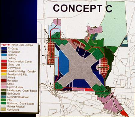
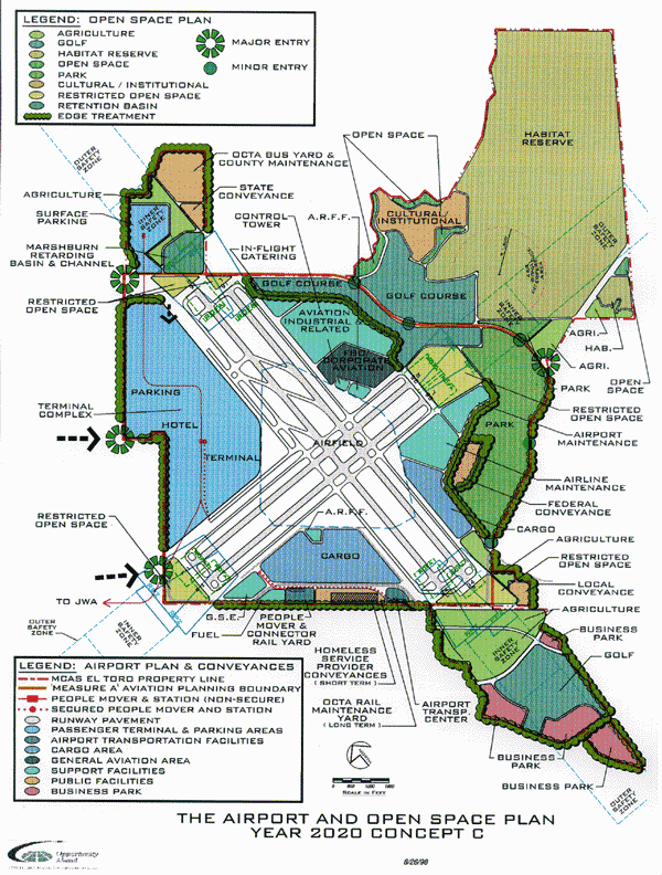
The Open Space/Airport Plan ("Green Plan") is the latest name for the airport project. Click here for a map showing how the 4,700 acres would be allocated. (File size 121K)
|
|
|
|
|
|